Activities such as construction of the shipping channel, the dumping of dredge spoils, the hardening of shoreline, and the destruction of shallow wetlands have resulted in a loss of over 95% of the Detroit River’s coastal wetlands. The protection and restoration of existing coastal wetland and aquatic habitat is a priority for the Detroit River Canadian Cleanup partnership. For more information, please visit our Annual Review (yearly reports) and DRCC Publications pages.
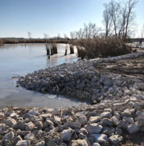 Collavino Wetland Restoration
Progress was made on restoring the Collavino wetland at the mouth of the Canard River. The Collavino wetland is 30.3 ha (75 acres) in size and has been designated as a Provincially Significant Wetland. In 2019, with funding support from ECCC, ERCA repaired the existing dyke and installed pumping infrastructure and water level control structures to manipulate water levels on the inside of the dyke. In 2021, the water levels were drawn down in the marsh to prepare for a prescribed burn to remove invasive Phragmites australis to enhance the wetland habitat for marsh birds and other wildlife. The prescribed burn took place in March 2022, successfully burning the dense Phragmites in the wetland. The plan is to flood the cell in the coming months to ensure the Phragmites does not return. Next year, the water levels will be drawn down to expose the native aquatic plant seedbed such as Arrowheads, Swamp rose mallow and common cattail, which is expected to increase native plant presence within the wetlands to improve habitat use by birds and other wildlife.
Fish Habitat Study
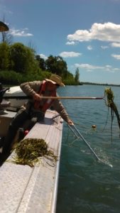 The DRCC Habitat Work Group, which is comprised of federal, provincial, local experts, and university researchers, has been working towards prioritizing areas in the Detroit River for potential fish habitat restoration projects. Many of these potential restoration actions include installing breakwaters to create slow water areas in order to encourage the establishment of vegetation, which makes good nursery habitat for young fish of many species.
Field researchers were on the river in July and August 2015 collecting data about fish communities, vegetation, sediment, and water quality at 22 of the potential restoration sites. DRCC partners then engaged an engineering consultant to more closely evaluate the feasibility of several of these projects.
Wetland Health and Marsh Birds
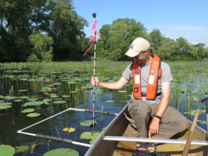 Since 2011, researchers have monitored coastal wetland habitat and marsh bird populations at selected sites in the Detroit River. By understanding populations of marsh birds and potential factors that affect marsh bird scores, the DRCC can assess the fish and wildlife populations and loss of wildlife habitat beneficial uses. Researchers collect data on water quality, submerged aquatic vegetation, aquatic macroinvertebrates and breeding marsh bird communities. Monitoring continued in the summer 2021 at seven wetlands on the Detroit River including MMM Hunt Club, Collavino and the 5 core sites. The research team completed data entry and is analyzing Indices of Biotic Integrity (IBIs).
IBIs are used to assess the habitat condition of wetland and nearshore areas in the Detroit River. These indices integrate complex ecological or community data into a single metric or score that can be tracked and understood. Previous results indicate that marsh bird IBI scores for Detroit River wetlands are low and the Canadian Wildlife Services (CWS) and Birds Canada are currently trying to determine reasons for the low marsh bird scores so that restoration actions can be implemented. The marsh bird scores overtime will be used to assist with the final evaluation of the Loss of Fish and Wildlife Habitat BUI #14.
Restoring Forests and Prairies
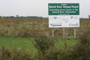 Since 2000, a total of 441 hectares (1,092 acres) of land has been restored in the Detroit River watershed through this program!All project decisions were guided by the priorities outlined in the Essex Region Natural Heritage System Strategy (ERNHSS) and are consistent with the habitat priorities of the Detroit River Remedial Action Plan (RAP).
Restoration Alternatives Selection Manual
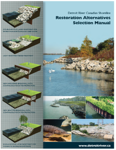 A manual was created to guide shoreline restoration efforts for private landowners working within the Detroit River AOC, and to assist the DRCC partnership in determining the suitability of various sites for implementing fish habitat enhancement works. The manual describes the various options for shoreline restoration that are possible along the Canadian side of the Detroit River for different project types. As well, it offers an easy-to-follow decision making matrix to help guide landowners, contractors, and the technical staff of various approving agencies to choose the best shoreline solution for a given site, based on common site characteristics.
Additionally, in 2016, the Shoreline Design Manual was updated to include a decision matrix and a map to help landowners decide which fish-friendly shoreline erosion protection techniques is best for them.
Naturalizing our Detroit River Shoreline
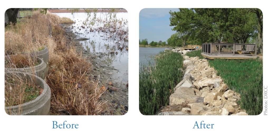
Shoreline hardening has resulted in the direct loss and fragmentation of natural habitat along the Detroit River shoreline – replacing it with reclaimed parkland, industrial land, housing, and other artificial structures such as seawalls. Most of this shoreline hardening along the Detroit River is considered unsuitable for many desirable species. In response to this, “soft” shoreline treatment techniques have become more prevalent in recent years, and involve the use of rock (and other natural materials) in combination with plants to resist erosion. Soft shoreline treatments more closely mimic the naturally occurring foreshores on the Great Lakes, and in doing so, provide greater environmental value. To date, the DRCC has conducted 14 shoreline habitat projects (summarized in Table below).
|
Number |
Location |
Project goals & description |
Date Completed |
|
1 |
NE Shore of Fighting Island, LaSalle |
Increased shoreline sinuosity by constructing groins that increased stability and enhanced habitat. |
1996 |
|
2 |
Dean Construction, LaSalle |
The project at the Dean Construction site included establishing a sediment forebay for stormwater runoff control and restoration of 550m of shoreline and naturalization, complimenting an existing wetland close to the site. This project was completed in 1999 through a partnership between Dean Construction and the Essex Region Conservation Authority. |
1999 |
|
3 |
Goose Bay, Windsor |
Goose Bay is one of the few remaining sheltered habitat embayments along the Upper Detroit River shoreline. The 172m shoreline project consisted of installing a sloping rock revetment with an undulating shoreline enhanced by rock benches, a sloping rock beach, shoreline wetland and submerged shoal features as well as riparian plantings. The project benefits aquatic communities through the reduction of wave energy due to the softened shoreline. |
2000 |
|
4 |
Windsor Riverfront (at Joan & Clifford Hatch Wildflower Garden) |
The project consisted of replacing the existing 472m of failing timber shoreline protection with a sloping rock revetment with an undulating shoreline enhanced by rock benches, a sloping rock beach, shoreline wetland and submerged shoal features as well as riparian plantings. The project benefits aquatic communities through the reduction of wave energy due to the softened shoreline, as well as an increased length of available shoreline. |
2001 |
|
5 |
St. Rose Beach, Windsor |
St. Rose Beach is one of the few remaining embayments along the upper Detroit River shoreline. The previously had a sheet steel wall as well as asphalt capped gabion baskets. The baskets were failing, resulting in shoreline instability. The 200m shoreline project restored and enhanced the shoreline of the embayment and construct additional submerged fish habitat. The restoration and rehabilitation work involved shoreline protection through rip-rap and native vegetation such as willows, dogwoods and other hardwood species. |
2001 |
|
6 |
Fort Malden, Amherstburg |
Due to the high energy from river currents and the wake of passing commercial freighters, Parks Canada identified the need to stabilize the shoreline to protect the fort’s historic earthworks. Since the shoreline was unstable and eroding, it also provided limited habitat values. Soft shoreline engineering replaced the sheet wall and gabion baskets. The site now features rock revetment with three shore connected offshore sheltering islands and groin structures. A variety of substrate sizes was incorporated and two submerged, offshore spawning shoals were constructed to provide habitat for lake sturgeon and other fish species. |
2004 |
|
7 |
McKee Park, Windsor |
Construction of large rock islands to protect the shoreline and embayment from the high-energy Detroit River water flow. A submerged reef was placed offshore for spawning by lake sturgeon and other fish species. Sheltering islands provide a low energy area sheltered from waves and boat wakes for fish to rest and feed. Sand and rounded stone (cobble) placed around these islands provide a living space for aquatic invertebrates (bugs) that in turn provide food for fish. A sand shoreline of sand and cobble (rounded stones) were added to provide a recreational feature as well as a place for fish, in particular young Lake Sturgeon to rest and feed. |
2004 |
|
8 |
Windsor Riverfront (Langlois to Moy) |
Improved long-term stability of the shoreline and enhanced fish habitat over 420m of shoreline from Lincoln Avenue to Langlois Avenue in the City of Windsor. The designs also facilitated the development of the riverfront park. |
2005 |
|
9 |
NW Shore of Fighting Island, LaSalle |
Stabilized shoreline to a depth of 37 cm with five-cm crushed limestone bound together with the Elastocoast product. |
2007 |
|
10 |
Centennial Park (Elm to Caron), Windsor |
In conjunction with a major erosion protection project, approximately 5,000m2 of fish habitat was created along the river. A 550-metre stretch of shoreline was softened directly up stream of the new Retention Treatment Basin (RTB). Failing wood crib walls were replaced, with irregular, undulating shoreline using a variety of rock sizes and shapes to significantly improve fish habitat while at the same time protecting the RTB from erosion. |
2010 |
|
11 |
Riverdance Park, LaSalle |
The existing shoreline consisted of vertical sheet steel walls and many abandoned finger docks. The rehabilitation work featured restoration of 550 metres of shoreline into an undulating shoreline, incorporating a variety of rock types and sizes, as well as a large offshore sheltering island. |
2010 |
|
12 |
Canard Park, LaSalle1 |
A variety of soft shoreline techniques including a diversity of stone types, shapes and sizes to create small spaces for fish eggs and invertebrates, increasing the overall shoreline length (by changing its shape) and creating a deep water pool to further improve fish habitat. A walking trail, two large viewing platforms and a fishing platform were constructed to enhance visitor experiences. The streamside area of the park was restored using native prairie plant species and trees |
2012 |
|
13 |
Lafarge Inc., Windsor |
Enhancement of 315 m shoreline at a major industrial site along the Detroit River. The work included placement of rock clusters as well as other fish habitat features. This shoreline project builds upon earlier riparian enhancements on the adjacent properties by Amico, Morterm Ltd. and Sterling Marine Fuels Ltd. |
2013 |
|
14 |
HMCS Hunter at Mill Street, Windsor |
Placed sloped armor stone along the shoreline to improve fish and aquatic habitat. Root wads were submerged in the calm water of the harbor to provide habitat for fish and turtles. |
2015 |
1 This project took place on the Canard River, a tributary of the Detroit River.
McKee Park Habitat Improvement
 The Detroit River is home for over 65 species of fish. In the winter of 2003/04, a number of improvements were made to the McKee Park shoreline to improve fish habitat. This included construction of large rock islands to protect the shoreline and create an embayment from the high-energy Detroit River water flow. A submerged reef was placed offshore for spawning by lake sturgeon and other fish species. Sheltering islands provide a low energy area sheltered from waves and boat wakes for fish to rest and feed. Sand and rounded stone (cobble) placed around these islands provide a living space for aquatic invertebrates that in turn provide food for fish. A sand shoreline of sand and cobble (rounded stones) was added to provide a recreational feature as well as a place for fish, in particular young Lake Sturgeon, to rest and feed. Partners on this project included the Essex Region Conservation Authority, Ontario Great Lakes Renewal Foundation, the City of Windsor, The Windsor Port Authority, the Environment and Climate Change Canada and the Great Lakes Sustainability Fund, Brighton Beach Power, ATCO Power and Ontario Power Generation.
Restoring Habitat for our River Giant
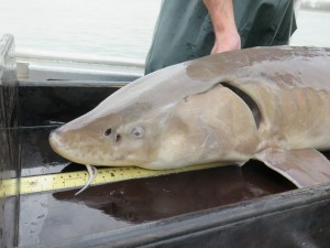 From the 1970s to 1990s, no lake sturgeon spawning was reported in the Detroit River, which, at one time, was one of the most productive sturgeon spawning grounds in North America. In an attempt to increase sturgeon populations and spawning within the Detroit River, both Canadian and American agencies collaborated on a sturgeon habitat restoration project in the Detroit River near the northeast tip of Fighting Island. Northeast Fighting Island was identified as one of the remaining areas for potential fish spawning habitat restoration in Canadian waters as it is a known historical sturgeon spawning area.
As part of this project, a total of 2.1 acres (0.89 acres in 2008 and 1.2 acres in 2013) of aquatic, deep water habitat was restored on the northeast tip of Fighting Island in the Detroit River. The first stage of the project (2008) constructed a boulder field and 12 individual reefs made up of four different rock types. The expansion phase of this project (2013) constructed one reef bed made up of one type of stone (6-12 inch limestone).
Post-construction monitoring of the first stage of this project found Lake Sturgeon spawning occurring in the first and second spring and for multiple years afterwards. In addition, reef monitoring showed Lake Whitefish, Walleye, and native sucker eggs present on the reef. This post-construction monitoring indicates that the spawning reef has continued to increase the productive capacity of spawning habitat for Lake Sturgeon (and other fishes) in the Detroit River. Further, this project has provided additional opportunities to improve our understanding of the presence, distribution, and ecology of Lake Sturgeon in the Detroit River. In 2017, it was estimated that there are over 6,000 Lake Sturgeon in the Detroit River, and over 30,000 in the Lake Huron to Lake Erie corridor.
This project is an excellent example of binational collaboration, partnership, and stewardship of shared resources. The success of this fish habitat restoration strategy will help strengthen and improve the fishery in the Detroit River and the entire Great Lakes. Credit for this successful project is owed to many project partners including Environment and Climate Change Canada’s Great Lakes Sustainability Fund, Ontario Ministry of Natural Resources and Forestry, the Ontario Species at Risk Stewardship Fund, DTE Energy, U.S. Fish and Wildlife Service, U.S. Geological Survey, University of Michigan Water Center, and the Great Lakes Restoration Initiative.


